
July 26, 2021
Redistricting is now upon us.
As the new LWVCT Champion for the People Powered Fair Maps© campaign, I decided to sketch out the redistricting terrain through a 5 part summer blog series. Each blog will include one or more actions you can take to get involved. In this first article I talk about what Redistricting is, why Redistricting exists, and how population changes as measured by the decennial Census are at the core of Redistricting. I begin with the basics and introduce resources and websites I’ll draw upon in later articles.
Thank you,
What is redistricting?
Districts are political administrative areas defined by processes specified in Federal and State law. The political administrative areas we call “towns” are related to but independent of these districts. Districts are drawn differently depending on the political unit in question. Connecticut has 5 Congressional (U.S. House) districts, 36 State Senate districts and 151 State House districts.
After each decennial Census, states are tasked with “Redistricting.” Redistricting is the process used to evaluate the map boundaries of U.S. Congressional and state legislative districts and, as necessary, redraw them to ensure each district includes a substantially equal number of people. Each Congressional, state Senate, or state House district can be said to have an “ideal” number of residents. The “ideal” population is simply the number that results from dividing the state’s total population by the number of districts for the given legislative body. For example, using the 2019 population estimate data available through Dave’s Redistricting App, Connecticut's “ideal” Congressional district size is 715,015, which is the CT population estimate divided by its 5 Congressional districts.
Why does Redistricting exist and how does the Census affect the process?
District boundaries must respond to changes in population, as measured by the decennial Census. At the Congressional level, decreased or increased population can lead to a state’s losing or gaining seats in the U.S. House of Representatives. In 1929, the total number of U.S. House seats was capped at the now-familiar 435 when Congress passed the Permanent Reapportionment Act. For example, see Our Common Purpose: Reinventing Democracy for the 21st Century. In order to stay within that limit of 435 seats and still keep districts of substantially equal population size, some states may gain or lose seats depending on the results of the most recent Census. The resulting districts remain in place for the next ten years, until the next Census.
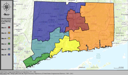
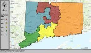
Connecticut's Congressional Districts Before and After the 2000 Census: 6 to 5
Population loss is the reason why Connecticut’s seats in the House of Representatives were reduced from six congressional seats to five after the 2000 Census. We will retain five districts following the 2020 Census. It’s easy to see why District maps had to be redrawn to reflect this change.
 |
 |
Thus far we have taken for granted that districts must be of “substantially equal” population size. Why is this the case? This principle was established in the 1960’s through a series of court cases. These cases established that “equal representation” in House and state legislative districts must be achieved on the basis of population and not on any other size basis such as land area. See the Public Mapping Project. In applying the principle to Congressional districts, the court has applied stringent definitions of “substantially equal”. In applying the principle to state legislative districts a deviation of up to 10% difference has been allowed.
This summary of Redistricting also underscores the importance of both who draws the maps and how they do this work.
Are maps drawn using transparent processes with ample opportunity for public engagement? Are maps completed by entities independent of elected officials or do legislators draw the districts in which they then run for office?
In many states including Connecticut, legislators are responsible for drawing the maps. In Connecticut, the process and timeline are embedded in the state Constitution (see the Connecticut General Assembly 2021 Redistricting Project Webpage). However, the Constitution is silent on both transparency and public engagement.
The “how” of Redistricting in Connecticut and alternative approaches taken in other states is the topic of my next Redistricting article, which you can access HERE.
Action you can take today:
- Become familiar with the resources on the Connecticut Committee on Reapportionment website.
- Post this blog article on your League’s website.
- Contact me redistricting [at] lwvct.org with any known Redistricting concerns in your area or any questions you may have.
Additional information:
There are many helpful websites on Redistricting; some are apps that encourage citizens to draw their own maps using local knowledge. Here are a few:
- League of Women Voters of the United States: People Powered Fair Maps
- Brennan Center for Justice: Redistricting in 2021
- Ballotpedia - Redistricting
- Loyola Law School - All About Redistricting